Image Data Formats
Geo-referenced image format
g-Space supports tiff, png, jpg, bmp formats coupled with world files. World files contain information about X and Y for each pixel of the image.
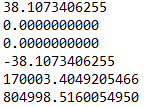
World file has 6 parameters:
- Line 1: A: x-component of the pixel width (x-scale)
- Line 2: D: y-component of the pixel width (y-skew)
- Line 3: B: x-component of the pixel height (x-skew)
- Line 4: E: y-component of the pixel height (y-scale), typically negative
- Line 5: C: x-coordinate of the center of the original image's upper left pixel transformed to the map
- Line 6: F: y-coordinate of the center of the original image's upper left pixel transformed to the map
File example:
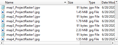
They must have same names as image files but different extensions and located in the same directory. Extensions have firs two characters of image file extension and additional 'w' at the end.
For more information can be found here World file - Wikipedia.
Raster basemap and satellite imagery (import)
Georeferenced basemap images (GeoTIFF / TIFF / PNG / JPG / BMP) can be loaded as a cultural background. Satellite imagery can also be downloaded directly from web XYZ map tiles and stored as a georeferenced GeoTIFF.
See Import images and Import satellite imagery.
Image export
g-Space can write images out as well:
- GeoTIFF - 3D post-stack seismic inline/crossline sections as georeferenced raster. See Export seismic to GeoTIFF.
- Workspace / view image (JPEG) - a rendered 2D / 3D / well-log view screenshot. See Export view image.