Move seismic data to constant datum or topography level (in depth domain)
![]()
![]()
The Shift Depth Data module is used to transfer seismic data (stack, gather) in the depth domain from one datum to another, allowing for accurate adjustment of seismic data for different reference levels. This module utilizes trace header values, constant values, mathematical expressions, or a new elevation map (imported as an additional input data set) to shift the data. It can also adjust the seismic data to the topography level, ensuring the dataset aligns with the actual surface or subsurface reference model.
![]()
![]()
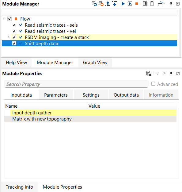
Input depth gather - input seismic gather in depth domain.
Matrix with new topography - optional, in case using mo to a matrix survey (or elevation map).
![]()
![]()
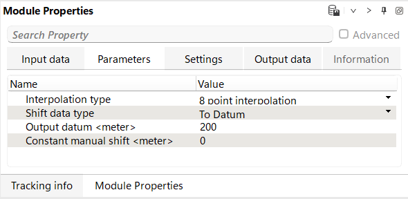
Interpolation type: select an algorithm for sample interpolation option that is used during vertical static shift applying. Recommendation to use: 8 point interpolation.
8 point interpolation - is a method of interpolation used in seismic data processing, where the value of a trace sample is estimated by considering the values of 8 surrounding points. This type of interpolation provides a more accurate representation of the seismic signal during processes like vertical static shifts because it takes into account more data points, reducing errors and improving the precision of the adjustment. In comparison to simpler methods, such as linear interpolation, 8-point interpolation results in smoother and more reliable data when applied to seismic traces.
Linear - is a simpler method of estimating a value between two known values by assuming a straight-line relationship between them. In seismic data processing, linear interpolation calculates the trace sample values by connecting two neighboring points with a straight line and estimating intermediate values based on this linear progression. While it is faster and computationally less expensive, it may not capture the complexity of the data as accurately as more advanced methods like 8-point interpolation, especially in the case of vertical static shifts.
Shift data type: select shift option:
To Datum - shift seismic data to particular datum in meters.
Const Shift - shift seismic data to within a constant value in meters.
To Floating Datum - shift seismic data to floating datum in accordance with trace headers (BIN_ELEV, important! BIN_ELEV in g-Platform system is a floating datum, and real (original) elevations are located in RECEIVER_ELEV and SOURCE_ELEV trace headers).
To Topography - shift seismic data to elevation datum in accordance with trace headers (RECEIVER_ELEV and SOURCE_ELEV, important! BIN_ELEV in g-Platform system is a floating datum, and real (original) elevations are located in RECEIVER_ELEV and SOURCE_ELEV trace headers).
By header - shift seismic data by any selected trace header.
By expression - shift seismic data by mathematical expression which may include trace headers. Example: SOURCE_STATIC + RECEIVER_STATIC.
To matrix elevations - shift seismic data in accordance wwith a new elevation survey (new map), that we can add in the Input parameters tab. Info: use Create interpolation matrix for creating a new map (input data can be trace headers or some ASCII file with XYZ format).
Output datum - define a new datum value in meters, in case of selected option is To Datum.
Constant manual shift - define a constant shift value in meters, in case of selected option is Const Shift.
Shift by header - select a trace header from which it will use a value for shifting, in case of selected option is By header.
Selection expression - define a new mathematical expression, result will be a value for shifting, in case of selected option is By expression.
![]()
![]()
Number of threads - limit number of threads on main machine.
Skip - switch-off this module (do not use in the workflow).
![]()
![]()
Output depth gather - output seismic gather in depth domain that was shifted to a new depth level.
![]()
![]()
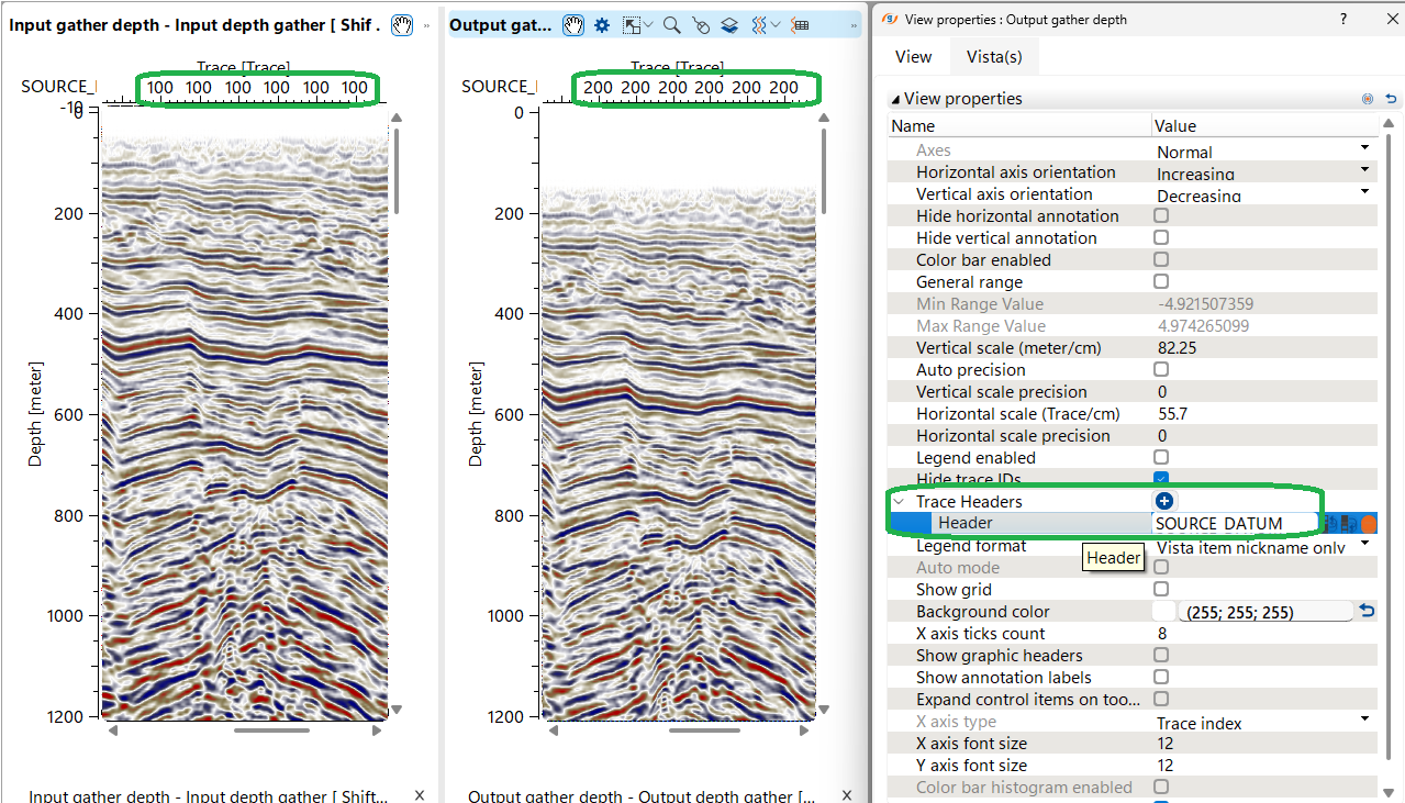
Workflow example: read seismic gather in depth domain, read interval velocity, create stack in depth domain and move to a new datum = 200 meters:
Show trace header SOURCE_DATUM on X abscissa to check the datum before and after shifting. Result:
![]()
![]()
YouTube video lesson, click here to open [VIDEO IN PROCESS...]
![]()
![]()
Yilmaz. O., 1987, Seismic data processing: Society of Exploration Geophysicist
 * * * If you have any questions, please send an e-mail to: support@geomage.com * * *