Module properties allows to setup all the process parameters implemented in g-Space
Changes made in Module Properties affect the active view immediately.
Module Properties has two states:
1. Process parameters - default state. Always active, except for seismic import
2. Import seismic parameters - launches during seismic import process where you can set the parameters for the import
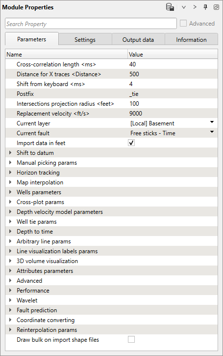
List of properties in default state:
Function Name |
Explanation |
Cross-correlation length <ms> |
Sets the length of the cross-correlation window in milliseconds. |
Distance for X traces <Distance> |
Defines the distance used for cross-correlation across traces. |
Shift from keyboard <ms> |
Allows manual input of shift values in milliseconds via the keyboard. |
Postfix |
Adds a postfix to the cross-correlation results. |
Intersections projection radius <feet> |
Sets the projection radius for intersections |
Replacement velocity <ft/s> |
Specifies the replacement velocity in m/ft per second |
Current layer |
Sets the selected horizon |
Current fault |
Sets the selected faul |
Import measurement system |
Sets the measurement system on import |
Shift to datum |
|
Datum time <feet> |
Sets the datum for data in time domain |
Datum depth <feet> |
Sets the datum for data in depth domain |
Manual picking params |
Opens parameters for manual picking settings |
Pick mode |
Sets the mode for picking (tracking, interpolation, etc.) |
Automatic picking window <ms> |
Defines the window for automatic picking in milliseconds |
Pick type |
Specifies the type of picking (e.g., peak, trough, zero-crossing) |
Magnet type |
Defines the magnet type for picking assistance |
Energy picking threshold <%> |
Sets the energy threshold for automatic picking in percentage |
Horizon track on bin change |
Enables horizon tracking on bin changes |
Horizon Tracking |
|
Inline/cdp start autopick |
Sets the starting inline/CDP for automatic picking |
Crossline start autopick |
Sets the starting crossline for automatic picking |
Inline/cdp end autopick |
Sets the ending inline/CDP for automatic picking |
Crossline end autopick |
Sets the ending crossline for automatic picking |
Inline/cdp step autopick |
Defines the step size for inlines/CDPs during automatic picking |
Crossline step autopick |
Defines the step size for crosslines during automatic picking |
Follow IL XL continuity |
Ensures continuity is followed along inlines and crosslines |
By corr |
Uses correlation for horizon tracking |
Map Interpolation |
|
Interpolation type |
Sets the type of interpolation used for map creation |
Interpolation step X <feet> |
Defines the interpolation step size in X direction |
Interpolation step Y <feet> |
Defines the interpolation step size in Y direction |
Current topography step X <feet> |
Defines the current topography step size in X direction |
Current topography step Y <feet> |
Defines the current topography step size in Y direction |
Use faults for map creation |
Includes faults in the map creation process |
Use internal points for map creation |
Uses internal points for map creation |
Fault clear radius <feet> |
Sets the map clearing radius around faults |
Kriging covariance |
Defines the covariance for Kriging interpolation |
Kriging range <feet> |
Sets the range for Kriging interpolation |
Kriging max points |
Defines the maximum number of points for Kriging interpolation |
Use polygons for map creation |
Includes the bounding polygon in the map creation process |
Polygons |
Manages the polygon used for map creation |
Wells Parameters |
|
Well projection radius <feet> |
Sets the projection radius for wells |
Well labels overlapping protection |
Enables protection to prevent well labels from overlapping |
Synthetic seis width <Trace> |
Sets the width of synthetic seismic traces |
Nearest seis type |
Specifies the type of nearest seismic data used (distance or number of traces) |
Nearest seis width <Trace> |
Sets the width of the nearest seismic traces |
Nearest seis distance <feet> |
Defines the distance for the nearest seismic data |
Selected seismic |
Sets the currently selected seismic data |
Selected seismic group |
Sets the currently selected seismic group |
Synthetic seismogram |
|
Create |
Sets the data for a synthetic trace generation (sonic log, sonic - density, etc.) |
Sonic |
Sets the sonic log data for synthetic seismogram creation |
Density |
Sets the density log data for synthetic seismogram creation |
Impedance |
Sets the impedance log data for synthetic seismogram creation |
Use anti-aliasing filter |
Applies an anti-aliasing filter to the logs data |
Update impedance on change checkshot |
Updates impedance when checkshot data changes |
Depth smooth <feet> |
Sets smoothing step to depth data |
Depth resample <feet> |
Sets resampling step to depth data |
Single well view template |
Defines the template for single well view |
Markers colors from stratigraphy |
Uses stratigraphy to color well markers |
Stratigraphy column |
Specifies the stratigraphy column used for markers |
LAS for Well color |
Sets the LAS to color wellbores in 3D view |
LAS for Well width |
Sets the LAS for wellbores width in 3D view |
LAS curve step |
Defines the step size for LAS curves |
Cross-plot Params |
|
Cross plot markers name |
Sets the marker to cross-plot |
Cross plot horizon name |
Sets the horizon to cross-plot |
Depth Velocity Model Parameters |
|
Datum <feet> |
Sets the datum level |
Max depth <feet> |
Defines the maximum depth for the model |
Depth step <feet> |
Sets the step size for depth |
Bottom velocity <ft/s> |
Defines the bottom velocity |
Velocity for constant model <ft/s> |
Sets the velocity for a constant model |
Create depth velocity from VRMS params |
|
Smooth along horizons |
Applies smoothing along horizons for velocity model creation |
Smooth along horizons window <Traces> |
Sets the window size for smoothing along horizons in traces |
Create constant layer depth velocity params |
|
Number of supersamples |
Defines the number of supersamples for constant layer depth velocity creation |
Well Tie Params |
|
Bottom taper <ms> |
Sets the bottom taper |
Max radius to well <feet> |
Defines the maximum radius to well |
Propagation taper min <feet> |
Sets the minimum taper for propagation |
Propagation taper max <feet> |
Sets the maximum taper for propagation |
Max velocity <ft/s> |
Defines the maximum velocity |
Min velocity <ft/s> |
Defines the minimum velocity |
Gradient type |
Sets the gradient type for well tie |
Checkshot welltie |
|
Max marker deviation from well <feet> |
Sets the maximum deviation for markers from the well |
Interpolation type |
Defines the interpolation type for checkshot welltie |
Trend/Voronoi/triangulation smooth <feet> |
Sets the smoothing type and range for trend, Voronoi, and triangulation. |
Kriging covariance |
Defines the covariance for Kriging in welltie |
Kriging range |
Sets the range for Kriging in welltie |
Marker type interpolation |
Specifies the interpolation type for markers |
Regression coeff |
Sets the regression coefficient for welltie |
Extrapolate checkshot |
Enables extrapolation of checkshot data |
(Checkshot + marker + horizon) Calculate velocity by checkshots |
Calculates velocity using checkshot, marker, and horizon data |
(Checkshot + marker + horizon) Add marker horizons |
Adds marker horizons to the checkshot and marker data |
(Checkshot + marker + horizon) Vrms creation step |
Sets the step size for Vrms creation from checkshot, marker, and horizon data |
Extrapolate deepest layer coeff |
Sets the coefficient for extrapolating the deepest layer |
Max distance to layer <feet> |
Defines the maximum distance to the layer |
Use wells and horizons inside polygon |
Uses wells and horizons within a specified polygon for calculations |
Use marker projection for detect velocity if marker not exist |
Projects marker data to detect velocity if the marker is absent |
Calculate velocity from topography |
Computes velocity starting from topography level |
Extrapolate check shot to 0 |
Extrapolates check shot data to zero |
Depth to Time |
|
DT <ms> |
Sets the depth to time conversion factor in milliseconds |
Max time <ms> |
Defines the maximum time for depth to time conversion |
Arbitrary Line Params |
|
Create arbitrary line |
Creates an arbitrary line |
Arbitrary line step <feet> |
Sets the step size for the arbitrary line |
Arbitrary line max search distance <feet> |
Defines the maximum search distance for the arbitrary line |
Straighten on 3D view |
Straightens the arbitrary line in the 3D view |
Line Visualization Labels |
|
Show |
|
Trace header |
|
Show header name |
|
Precision |
Sets the precision for line visualization labels. |
Step <feet> |
|
3D Volume Visualization |
|
Step inline |
Defines the step size for inlines in 3D volume visualization |
Step crossline |
Defines the step size for crosslines in 3D volume visualization |
Step time <ms> |
Sets the time step size in milliseconds for 3D volume visualization |
Step depth <feet> |
Sets the depth step size in feet for 3D volume visualization |
Current inline |
Sets the current inline being visualized |
Current crossline |
Sets the current crossline being visualized |
Current time <ms> |
Sets the current time for slice visualization |
Current depth <feet> |
Sets the current depth for slice visualization |
Attributes Parameters |
|
Amplitude |
Computes the amplitude attribute |
Envelope |
Computes the envelope attribute |
Instantaneous phase |
Computes the instantaneous phase attribute |
Instantaneous unwrap phase |
Computes the unwrapped instantaneous phase attribute |
Instantaneous frequency |
Computes the instantaneous frequency attribute |
Frequency derivative |
Computes the frequency derivative attribute |
Instantaneous bandwidth |
Computes the instantaneous bandwidth attribute |
Cosine of instantaneous phase |
Computes the cosine of the instantaneous phase attribute |
Dominate frequency |
Computes the dominant frequency attribute |
Thin bed indicator |
Computes the thin bed indicator attribute |
Envelope derivative |
Computes the derivative of the envelope attribute |
Second derivative of envelope |
Computes the second derivative of the envelope attribute |
Instantaneous Q |
Computes the instantaneous Q attribute |
Coherence |
Computes the coherence attribute |
Chaos |
Computes the chaos attribute |
Seismic relief |
Computes the seismic relief attribute |
Check/uncheck all attributes |
Toggles the selection of all attributes for calculation |
Selected horizon |
Sets the horizon selected for attribute calculation |
Time window <ms> |
Sets the time window for attribute calculation |
Calc type |
Defines the type of calculation for attributes (map or the entire volume) |
Advanced |
|
Merge stack line distance <feet> |
Sets the distance for merging seismic volumes/lines into the single survey |
Max distance picking projection <feet> |
Defines the maximum distance for picking projection |
Turn on undo |
Enables the undo feature |
Fill gaps in volume |
Fills gaps in the volume data |
Performance |
|
Show well names on location map |
Displays well names on the location map |
Show las curves on seismic views |
Displays LAS curves on seismic views |
Update horizon phase maps |
Updates the horizon phase maps |
Show cube slice on 3D view |
Displays a slice of the cube in the 3D view |
Update horizons 3D view |
Updates horizons in the 3D view |
Update volume 3D view |
Updates the volume in the 3D view |
Update maps and faults after adding stick |
Updates maps and faults after adding a stick |
Use only live traces for 30 data contouring |
Uses only live traces to create the volume polygon |
Show well table |
Displays the well table |
AVO real time update on polygons |
Updates AVO data in real time on polygons |
Wavelet |
|
Convert to min phase |
Converts the wavelet to minimum phase |
Wavelet length <ms> |
Sets the length of the wavelet |
Wavelet Sample rate <ms> |
Sets the sample rate of the wavelet |
Ricker type |
Specifies the type of Ricker wavelet |
Dominant frequency <Hz> |
Sets the dominant frequency of the wavelet |
Detect time start <ms> |
Defines the start time for wavelet detection |
Detect time end <ms> |
Defines the end time for wavelet detection |
Fault Prediction |
|
Correlation time window <ms> |
Sets the time window for cross correlation |
Correlation bin window |
Sets the bin window for cross correlation |
Maximum shift <ms> |
Defines the maximum shift allowed in fault prediction |
Time stretch <%> |
Specifies the time stretch percentage for fault prediction |
Sigma for local faults |
Sets the sigma value for local fault detection |
Sigma for generalized faults |
Sets the sigma value for generalized fault detection |
Sigma for noise reduction |
Sets the sigma value for noise reduction |
Autopicking step |
Defines the step size for autopicking |
Coordinate Converting |
|
Use converting on import |
Applies coordinate conversion on data import |
Reinterpolation Params |
|
Do reinterpolation |
Enables reinterpolation of data |
Reinterpolation radius <feet> |
Sets the radius for reinterpolation in feet |
Number of taken bins |
Defines the number of bins taken for reinterpolation |
Draw bulk on import shape files |
Draws bulk data on import of shape files |
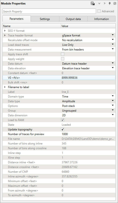
List of properties in the Seismic data workspace:
Function Name |
Explanation |
SEG-Y Format |
|
Data type |
Specifies the type of data in the SEG-Y format (land, marine, etc.) |
Text header size |
Defines the size of the text header in the SEG-Y file |
Binary header size |
Defines the size of the binary header in the SEG-Y file |
Endian |
Specifies the byte order (endianness) of the data |
EBCDIC |
Indicates whether the text header is in EBCDIC format |
Data Sample format |
Specifies the format of the data samples in the SEG-Y file (int, float, etc.) |
Trace Header Format |
Sets the trace header format from the list |
Recalculate offset mode |
Sets the mode for recalculating offsets in the trace headers |
Load dead traces |
Option to load or not dead traces from the SEG-Y file |
Data measurement |
Specifies the measurement units for the data |
Apply trace shift |
Applies a shift to trace data |
Apply weight |
Applies a weight factor to trace data |
Data datum |
Sets the datum level for the data (e.g. constant, floating) |
Data elevation |
Sets the topography level for the data |
Constant datum <feet> |
Specifies a constant datum level |
VO <ft/s> |
Specifies the replacement velocity (VO) |
Bulk shift <ms> |
Applies a bulk shift to the data |
Filename to Label |
|
First char |
Specifies the first character position used for labeling |
Number of chars |
Defines the number of characters used for labeling |
Label |
Displays the current label |
Domain type |
Specifies the domain of the data (time or depth) |
Data type |
Specifies the type of data (amplitude, velocity, etc.) |
Options |
Defines data type between pre-stack and post-stack |
Group |
Specifies the data group (e.g. PSTM, PSDM) |
Data dimension |
Defines the dimension of the data (2D or 3D) |
Load to RAM |
Option to load data into RAM |
State |
Displays the state of loading data into the project |
Update topography |
Updates the topography data after loading SEG-Y |
Number of traces for preview |
Specifies the number of traces to preview |
File name |
Displays the name of the file being processed |
Number of bins along inline |
Displays the number of bins along the inline direction |
Number of bins along crossline |
Displays the number of bins along the crossline direction |
Inline step |
Displays the step size for inlines |
Xline step |
Displays the step size for crosslines |
Distance Inline <feet> |
Displays the distance between inlines |
Distance crossline <feet> |
Displays the distance between crosslines |
Number of CMP |
Displays the number of common midpoints (CMP) in the data |
Inline azimuth <degree> |
Displays the azimuth angle for inlines |
Minimum offset <feet> |
Displays the minimum offset distance |
Maximum offset <feet> |
Displays the maximum offset distance |
From azimuth <degree> |
Displays the starting azimuth angle |
To azimuth <degree> |
Displays the ending azimuth angle |