Geomage g-Space™ User Manual
  • Introduction
  • Installation
    • Requirements
    • Installation steps
    • Licensing
    • Software update
  • User Interface
    • Ribbon bar
      • Main bar
      • Views bar
      • Database
      • Seismic bar
      • Wells bar
      • Petrophysics
        • Base properties
        • Shale Volume
        • Porosity
        • Saturation
        • Pore pressure
        • Lithology
        • ML Log Prediction
        • Mineral Volume Estimation
      • Well tie bar
      • Interpretation
      • Velocity model bar
      • Modelling
      • Attributes bar
      • Statistical analysis bar
      • Mis tie seismic bar
      • AVO bar
      • Reservoir bar
    • Panels
      • Data Manager
        • Seismic 2D
        • Seismic 3D
        • Arbitrary lines
        • Wells
          • Create curve
          • Load raster
          • Scale Curves
          • Extract seismic trace
        • Well sections
        • Markers
        • Stratigraphy
        • Horizons
        • Faults
        • Topography
        • Raster files
          • Satellite imagery downloader
        • Shapefiles layers
        • Maps
        • Structural Models
        • Velocity model
        • Polygons
        • 3D Grids
          • 3D Grid Quality Control
        • Geo-bodies
        • Multi-Z Surfaces
        • Wavelets
        • Fault model
        • Points
      • Filter wizard
      • View Manager
      • Conceptual Model
      • Module Properties
      • Visual Settings
        • View
        • Object
      • Actions
      • Output View
      • Progress View
      • Object properties
    • Workspace
      • Views synchronization
      • Seismic data workspace
      • Wells data workspace
    • Views
      • Location map
      • Seismic view
      • 3D view
      • AVO views
        • Image gather
        • AVA gather
        • 3D image gathers
        • AVO cross-plot
        • AVO graph
        • Stack gather
      • Table view
      • Well tie view
      • Well correlation view
        • LAS editing
        • Working with Palettes
      • Graphs
        • Histogram view
        • Cross plot view
        • Pine graph view
        • Variogram view
        • Stereonet view
      • Map editor
    • Controls and shortcuts
    • Seismic data
  • Getting Started
    • Creating a new project
    • Saving the project
    • Loading an existing project
    • Closing the project
    • Project configuration
      • Coordinate and measurement system
      • Datum configuration
    • Demo project
    • Remote database
  • Import data
    • Import Seismic
      • Import attributes
      • Import ZGY
      • Convert ASCII to seismic
      • Import mistie cross-points
      • Import mute picking
      • Import GSD
      • Import other seismic formats
    • Import Wells
      • Create well
      • Import well headers
      • Import inclinometry
      • Import markers
      • Import markers structure
      • Import LAS files
      • Import checkshots
      • Import comment log
      • Import DLIS
      • Import WITSML
      • Import PRODML
      • Import from OSDU
      • Import stratigraphy
      • Import marker ages
      • Import well log images
    • Import Horizons
    • Import Faults
    • Import Shapefile
    • Import polygons
    • Import topography
    • Import images
      • Import satellite imagery
    • Import maps
    • Import grids
      • Import 3D models
      • Import RESQML
      • Import DXF
    • Import points
    • Import from g-Platform
  • Export data
    • Export well headers
    • Export inclinometry
    • Export markers
    • Export markers structure
    • Export checkshots
    • Export las
    • Export comment log
    • Export horizons
    • Export faults
    • Export maps
    • Export grids
      • Export 3D models
      • Export RESQML
      • Export to VTK
      • Export DXF
    • Export polygons
    • Export mistie cross-points
    • Export mute picking
    • Export seismic
    • Export seismic to GeoTIFF
    • Export marker ages
    • Export well logs to Excel
    • Export points
    • Export shapefile
    • Export view image
    • Export to g-Platform
  • Formats
    • Well Data Formats
    • Seismic Data Formats
    • Horizon Data Formats
    • Maps Data Formats
    • Fault Data Formats
    • Image Data Formats
    • GIS Data Formats
    • Grid Data Formats
    • GOCAD Data Formats
    • Trace headers math
    • Model Data Formats
    • Point Data Formats
  • Service Tasks
  • Best Practice Flows
    • Workflows
    • Well log correlation
      • Setting Up a Well Template
      • Working with Markers
      • Well log calculator
    • Lithology Interpretation
    • Well-Tie
    • Seismic picking
      • Seismic data visualization
        • 2D data
        • 3D data
      • Horizon picking
      • Fault picking
        • Fault prediction
        • AI Faults Wizard
    • Velocity model workflow
      • Setting up the velocity model
        • Constant
        • Constant layered
        • Markers + horizons
        • Grid velocity by markers + horizons
        • Checkshot extrapolation
        • Checkshot + markers
        • Checkshot + markers + horizons
        • From Vrms
      • Velocity model QC
      • Import velocity model
      • Export velocity model
    • Seismic attributes
      • Spectral decomposition
    • Gather conditioning
    • AVO
    • Mis-tie correction
      • 2D mis-ties correction
      • 3D mis-ties correction
    • Mapping
      • Map creating
      • Map editing
    • Statistical analysis
      • Cross plot
      • Histogram
      • Variogram
      • Stereonet
    • Geological modeling
    • 3D grid creating
    • Properties modeling
      • Seismic Data Upscaling
      • Upscale 3D Grid
    • Volumetric calculations
    • Multi-user mode
    • Structural modeling
      • Structural Uncertainty Analysis
    • Python scripting
    • Well Data QC and Verification
User Interface › Views › AVO views
Top ← Previous Next →

AVO views

AVO views group is the set of views where user can visualize pre-stack seismic data and analyze it using graphs and cross-plots


AVO includes following windows:

Image gather

AVA gather

3D image gathers

AVO cross-plot

AVO graph

Stack gather

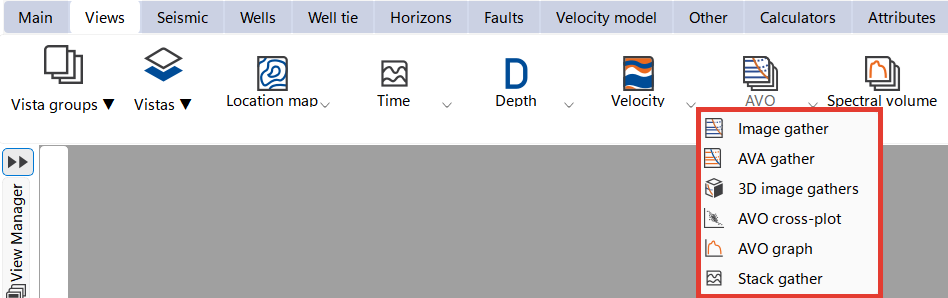
To create AVO section view go to the  Views bar on the Ribbon bar and open AVO tab and choose the view that you prefer for data visualization
views_bar_AVO_tab.png