Well Data Formats
This chapter summarizes well data formats currently supported by g-Space
All table data can be easily copied using Ctrl+C and pasted into any external application (e.g., Excel, Notepad) in table format.
Well headers format
Well header data can include the well name, Unique Well Identifier (UWI), X and Y coordinates, Kelly bushing (KB), total depth (TD), Type and Status as separate fields, ground level (GL), company name and completion date.
Supported formats are:
- TAB delimited
- Space delimited
- Comma separated (CSV)
- Petrel well head text files
For more information about loading these formats into g-Space see Import well headers
Well deviation (inclinometry) data format
Well deviation contains the information about well trajectory of the well such as Measured Depth (MD), Inclination (INCL), Grid azimuth (AZIM).
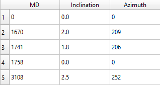
Supported formats are:
- TAB delimited
- Space delimited
- Comma separated (CSV)
For more information about loading well trajectory into g-Space see Import inclinometry
Well markers format
g-Space supports two marker table layouts:
MD layout: provide UWI or Well Name, Marker and MD.
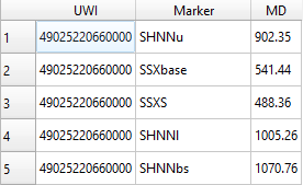
XY layout: provide UWI or Well Name, Marker, X, Y, and either TVD or TVDSS.
Age and Type can also be mapped when present.
Petrel well-tops text files are also supported. When their columns are declared between BEGIN HEADER and END HEADER, g-Space detects the layout and maps the standard columns automatically.
Supported formats are:
- TAB delimited
- Space delimited
- Comma separated (CSV)
- Petrel well-tops text
For detailed field mapping and loading steps, see Import markers.
Well markers structure format
This is the g-Space binary format with extension *.msstruct which stores markers hierarchy
For more information about loading markers structure into g-Space see Import markers structure
LAS format
LAS format contains the information of the well log data (continuous or discrete)
The description of this file format is given here: https://www.asprs.org/a/society/committees/standards/asprs_las_format_v12.pdf
For more information about loading LAS files into g-Space see Import LAS files
Checkshot format
Checkshot data files store depth-time relationships. For a standard table, map TVD and Time, and optionally UWI; the import settings let you identify OWT or TWT and seconds or milliseconds. Petrel checkshot files are detected automatically.
Supported formats are:
- TAB-delimited checkshot tables
- Petrel checkshot files (*.txt, *.dat, *.las, *.checkshot)
For more information about loading checkshots into g-Space see Import checkshots
Comment log format
Comments log format contain the information about comments at specific depth in text format. WELL NAME-->MD-->Comments (text)
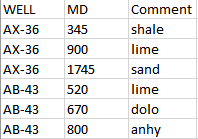
Supported formats are:
- TAB delimited
For more information about loading comment log into g-Space see Import comment log
Log Files (Text) format
Columnar log data can also be loaded from plain text files using the Log Loading Wizard. Each column holds one log curve sampled against depth.
Supported formats are:
- TAB delimited
- Space delimited
- Comma separated (CSV)
DLIS format
DLIS (*.dlis) files store well log curves in a binary industry format. g-Space reads DLIS with a native reader and loads the curves through the same file dialog used for LAS files.
For more information see Import DLIS
WITSML and PRODML formats
WITSML is an XML-based industry standard for well data. On import it can carry wells / wellbores, well headers, logs / curves, deviation and trajectory, and formation markers. PRODML import loads well comments into existing wells and point sets from orphan coordinates.
For more information see Import WITSML and Import PRODML
OSDU data model
g-Space can import from the OSDU data platform (JSON *.json). A single import can carry wells, wellbores, deviation / trajectory, logs / curves, markers / tops and point sets.
For more information see Import from OSDU
Well trajectory format
In addition to the MD/INCL/AZIM deviation format above, well trajectory stations can be loaded from a *.wt file, and Petrel deviation surveys from *.dev files.
For more information see Import inclinometry
Well raster log images
Scanned paper logs can be loaded as georeferenced raster images (PNG / JPG / JPEG / BMP / XPM). A single image can be loaded on its own, or many images can be loaded in bulk using an XML manifest.
For more information see Import well log images
Export formats
Well data can be exported from g-Space in the following formats:
- LAS - well log curves (all wells or selected curves, with a re-sampling option). See Export las.
- Excel workbook (*.xlsx) - well log curves. See Export well logs to Excel.
- Well headers, inclinometry, markers, checkshots and comment log - as TAB / CSV text tables (see the corresponding Export topics).