Import maps
There are five ways to import maps files into the project:
1. Load from text file
2. Load from text file (irregular)
3. Load from CPS-3 grid file
4. Load from ZMap grid file
5. Load from IRAP classic grid file (*.irap / *.gri / *.txt)
In Data manager in Maps icon decide in which set of maps data will be loaded. Press right mouse button and choose one of the load commands:
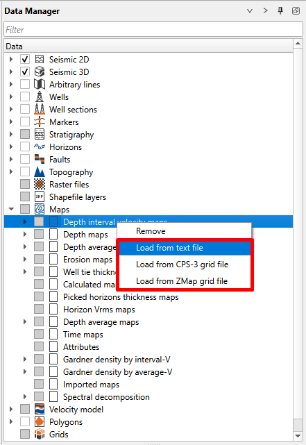
The CPS-3, ZMap and IRAP classic grid loaders let you select several files at once in the load dialog. Each selected file is imported as a separate map into the chosen set of maps. The plain text-file loaders load one file at a time.
An imported map is named after the file it comes from: g-Space uses the file name without its extension as the map name in Data manager. For example, the file Map_ConInt.cps3 gives a map called Map_ConInt. For CPS-3 files the grid name written in the file header is not used.
When you load a single file, the Set name of the loaded map dialog opens with this name already suggested in Loaded map name, so you can keep it or type another one. When several files are selected at once, no name is asked and each map keeps the name of its own file. The Load from text file (irregular) import wizard suggests the same name in its Map name field.
If the chosen set of maps already contains a map with the same name, a number is added to the new name to keep it unique, for example Map_ConInt (1).
The Load from IRAP classic grid file loader keeps the rotation angle written in the file header, so a rotated grid is imported with its original orientation. CPS-3 and ZMap files do not carry a rotation angle, so choose the IRAP classic format when the orientation of a rotated grid has to be preserved. When the file coordinates are converted to the project coordinate system on import (Imported EPSG code and Use converting on import in the load dialog), the corner coordinates, the cell sizes and the rotation angle are converted together, so the grid keeps its shape and its orientation.
An IRAP classic file that is truncated or contains a value that is not a number is refused as a whole, so a partly read grid never appears in the project. The message names the file, the number of samples expected for the grid size given in its header and the number actually read. When several files are selected at once, the other files are still imported and the messages for the refused ones are shown together.
For more information about grid formats supported by g-Space refer to Maps Data Formats