Export markers
There are two options for exporting markers: Export Wells Markers to Text File for exporting standard well markers, and Export Well-Tied Horizons-Markers to Text File for exporting markers after performing a Well tie.
In Action panel choose Export wells markers to text file
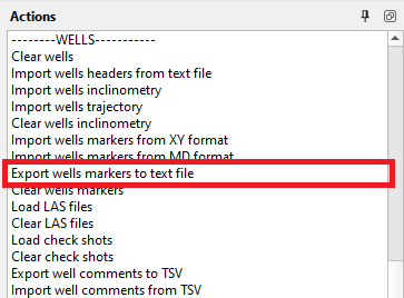
Locate file directory and click Save
It's also an option to export markers from Wells bar

For more information about well markers format please refer to chapter Well Data Formats
Markers Export from the Data Manager
You can also export a marker set directly from the Data Manager. Right-click the marker set and choose Markers Export.
This opens the Markers Export Setup wizard, which follows the same style as the Well Headers and Well Inclinometry export wizards. Under Select fields to export: tick the marker fields/columns you want to include, then click OK and choose the output file. Use Select All or Deselect All to check or clear every field at once.
Any custom marker attributes defined on the marker set are listed as additional fields in the wizard, so they can be exported as well. They are ticked when the wizard opens, just like the standard fields, and each ticked attribute is written as an extra column after the standard columns, in alphabetical order. Custom attribute columns are added in the same way when you use Export wells markers to text file.
The exported file will contain the following standard marker information by default:
- UWI: Unique Well Identifier
- Wellname: Name of the Well
- Marker: Marker Name or Identifier
- X: Easting (X coordinate)
- Y: Northing (Y coordinate)
- MD: Measured Depth
- Age: Age of the Formation
- TVD: True Vertical Depth
- TVDSS: True Vertical Depth Subsea
- TWT_CRD: Two-Way Travel Time (Corrected Datum)
- TWT_SRD: Two-Way Travel Time (Sea Reference Datum)
- Type: Type of Marker
- Unconformity: Indicates Unconformity Type or Status