Export DXF
DXF (Drawing Exchange Format) is the AutoCAD interchange format. g-Space exports polygon and geobody geometry to .dxf files so the data can be opened in AutoCAD and other CAD/GIS packages. Writing is handled internally by the bundled libdxfrw library.
Purpose
Write g-Space polygons (and geobody outlines) out as AutoCAD DXF geometry. Each polygon is exported as a closed polyline on its own layer, with a text label at the polygon centroid. Export requires a Seismic Interpretation license.
Launching the export
Export is launched from the Data manager context menu. Right-click one or more polygons, or the polygons group, and choose one of:
- Export to DXF file - exports the selected polygon.
- Export all polygons to DXF file - exports every polygon in the group. On the Polygons category this command is in the Export submenu.
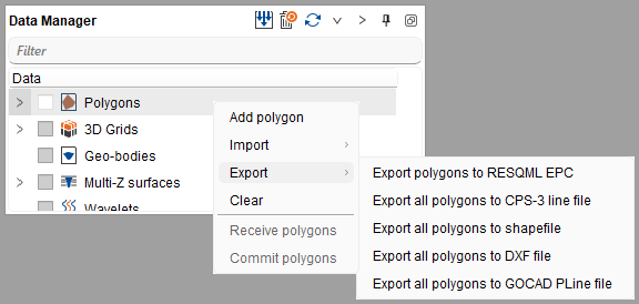
Step-by-step
- Select the polygon(s) to export in the Data manager and open the context menu.
- Choose Export to DXF file or Export all polygons to DXF file.
- In the Save Polygons to DXF file dialog, pick a location and file name. The .dxf extension is added automatically if you omit it.
- Confirm to write the file. Open the resulting .dxf in your CAD/GIS application to verify the geometry.
[image: placeholder_Save_Polygons_to_DXF_file_dialog_with_th.png]
Notes
- Files are written in AutoCAD AC1024 (2010) DXF format.
- Each polygon becomes a closed LWPOLYLINE placed on a layer named after the polygon's owner (or the polygon name when no owner is set).
- A TEXT label with the polygon name is written at the polygon centroid on a dedicated Labels layer.
- Polygon coordinates are written in the project coordinate system; DXF stores no CRS metadata, so record the units and datum separately if the file will be shared.
See Also