Import DXF
DXF (Drawing Exchange Format) is the AutoCAD interchange format. g-Space imports .dxf files that carry polygon outlines and geobody (3D surface) geometry. Reading is handled internally by the bundled libdxfrw library, so no external CAD software is required.
Purpose
Bring geometry authored in CAD tools into a g-Space project. Two kinds of objects are read from DXF: closed polylines are imported as polygons, and 3D face meshes are imported as geobodies (free 3D surfaces). Import is read-only and requires a Seismic Interpretation license.
Launching the import
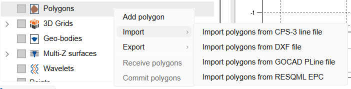
Both importers are launched from the Data manager context menu. Right-click the target group and choose:
- Import > Import polygons from DXF file - loads closed polylines into the polygons group.
- Open DXF files (from the geobodies group) - loads 3D face geometry as geobody surfaces.
Step-by-step
- In the file dialog, keep the filter on DXF files (*.dxf) and select one or more .dxf files.
- For polygon import, set the coordinate reference system and measurement system in the dialog's additional options. DXF files carry no coordinate-system metadata, so confirm the file coordinates and units match the project.
- For geobody import, tick Invert Z axis if the DXF Z values should be flipped to match the project's depth convention.
- For polygons, choose which DXF layers to import in the Select DXF layers to import dialog. All polylines on the selected layers are imported; TEXT labels sitting inside a closed polyline supply its name.
- Confirm to load. Imported polygons appear in the polygons group and imported geobodies in the geobodies group of the Data manager.
[image: placeholder_Select_DXF_layers_to_import_dialog_listi.png]
Notes
- Polygon import reads LWPOLYLINE and POLYLINE entities; the closed flag on the entity sets whether the resulting polygon is closed.
- Geobody import reads 3DFACE entities and stitches them into a single triangulated free surface per file.
- Polylines with no name text fall back to a <layer>_<index> name; geobodies are named after the file.
- DXF import does not store a coordinate system, so imported points are treated in the project CRS you select at import time.
See Also